The Réseau Express Régional (RER) is a rapid transit system serving Paris and its suburbs. The RER E is one of the RER’s five lines and is being extended further west of Paris.
The project includes three new stations of the line, one of which is Nanterre–La Folie, located between an express road near La Défense business district and the Groues district, a brownfield industrial site currently undergoing urban renewal.

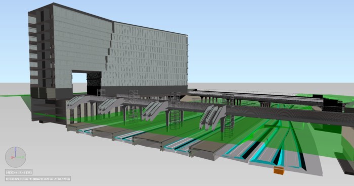
EOLE project – Dynamic cross section – Dynamic cross section of the station. We can see on this image, the station, the footbridge, the platforms, the railway corridor and Hebert bridge. Image courtesy of ARCADIS
This project was submitted to the 2015 Excellence in Infrastructure Awards Program. To learn more about the program and submit for 2016, visit the awards program site – AEC Excellence Awards.
Unique challenges
The project is quite unique by the number of stakeholders in the area and the precise coordination that the design and then construction will require.
This project includes a lot of different quite of works:
- Buildings
- Bridges (new bridge and replacement of an existing bridge)
- Footbridge
- Platforms
- Retaining walls
- Railway corridor (including tracks and electrical networks)
- Roads
- All the networks of the area (electrical, drainage)
The Solution
Arcadis is leading the design effort for the new station, using a variety of Autodesk® tools, including Autodesk® Revit®, Autodesk® AutoCAD® Civil 3D®, Autodesk® AutoCAD®, Autodesk® Navisworks®, Autodesk® InfraWorks® 360, Autodesk® Revit® Server, and Autodesk® Buzzsaw® software.
The project includes a wide range of works, from railway corridors, roads, and bridges to buildings, platforms, and utilities. In its complex urban setting, with these multiple design disciplines and project stakeholders, the design team is using model-based design and construction for project coordination, communication and visualization, and clash detection. Moreover, integrated collaboration tools and centralized project models help Arcadis efficiently access and distribute up-to-date project information.
Watch the video of the project here:
[youtube https://www.youtube.com/watch?v=Adho3eTRU3M?feature=oembed&w=585&h=329]
The results

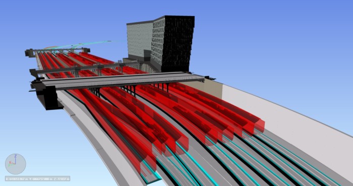
EOLE project – Clearance checking – On this image, we can see the clearance checking under the bridges thanks to the trains modeling. Image courtesy of ARCADIS
Benefits of BIM
- Model based workflows – Many design issues were detected thanks to the modelling of all the objects. This model-based workflow allowed to client to save a lot of money. Indeed, these issues would have cost a huge amount of money if it had to be solved during the construction phase.
- Every draftsman works with updated elements from each member of the team which means there are never versioning problems
- The BIM manager the team was able to quickly and easily the search information from the database.
- Integrated analysis
- Quantities have been automatically extracted from the model, freeing up time for the designers to consolidate the design.
- Clash detection have been proceeded to check the coherence of the project both internally and in between the different objects.
- Simulation
- One of the bridges had to be replaced (destroyed then rebuilt). The specific challenge of this part of the project is minimizing impact to road traffic.
- Required to define a very complex and specific construction phasing with a lot of intermediate and temporary retaining structures.
- The 4D simulation from Navisworks helped the design team to find the most relevant solution.
- Visualization – the client had a better understanding of the entire project. Moreover, the model help the client to communication about the project. Finally the model integrated in its environment was the perfect tool to check visibility range
Project results
- Time savings – Huge time savings in creating 2D drawings for the clients thanks to Revit. Then the entire team had more time to spend on the design.
- Money savings – All the models have to be modelled once but then they can be used for a lot a different things : 2D drawings, visualization, cost estimation, quantities, simulations. Money have been saved thanks to the use of models.
- Project performance and delivery
- Every draftsmen had access to all the information needed during design. This reduced the number of emails exchanged because all information was located in the RevitServer. Each data was unique and each data was up-to-date.
- Every 2D drawing created was coordinated.
What’s new?
Stay up-to-date on the latest releases for Autodesk InfraWorks 360, AutoCAD Civil 3D or Autodesk Revit at the links below:
www.autodesk.com/campaigns/whats-new-infraworks-360
www.autodesk.com/campaigns/whats-new-civil-3d
www.autodesk.com/campaigns/whats-new-revit
More rail & transit here.
The post Vertical and horizontal BIM for transit appeared first on BIM on the Rocks.


Leave a Comment
You must be logged in to post a comment.